
This week we read another double portion, Acharei Mot and Kedoshim. The latter, literally meaning “holies”, instructs us on the key mitzvot that make us especially holy. Of course, while all of the Torah’s mitzvot serve to make us holier, the ones in Kedoshim particularly have special merits. The list starts with revering one’s parents and observing the Sabbath (Leviticus 19:3). It peaks with the famous mitzvot of judging others favourably (v. 15), not gossiping (v. 16) nor bearing a grudge (v. 18), and loving your fellow as yourself. Other big mitzvot include not wearing shaatnez (v. 19, a mixture of wool and linen), and not getting tattooed (v. 28). Finally, there is a list of prohibited sexual relationships, before God says:
And you shall observe all My statutes and all My ordinances, and fulfill them, so that the Land, to which I am bringing you to dwell therein, will not vomit you out. You shall not follow the practices of the nations that I am sending away from before you, for they committed all these, and I was disgusted with them. So I said to you: You shall possess their land, and I shall give it to you to possess it, a land flowing with milk and honey. I am the Lord your God, Who has separated you from the nations.
And you shall distinguish between clean animals and unclean ones, and between unclean birds and clean ones; thus you shall not make yourselves defiled through [unclean] animals and birds and any [creature] which crawls on the earth, that I have distinguished for you to render unclean. And you shall be holy to Me, for I, the Lord, am holy, and I have separated you from the nations, to be Mine. (Leviticus 20:22-26)
God tells us that the Canaanites defiled themselves with all of these abominable sins, which is why He is banishing them from the Holy Land. God warns Israel that they should not fall into such sin, otherwise the Land will “vomit” them out, too. The Land of Israel is a special place, unlike any other. It does not tolerate sin. The parasha concludes with God emphasizing once more the importance of consuming only kosher food, for this is a major source of defilement. Twice, God repeats that He has separated the people of Israel from the other nations, to be a holy people.
From this and other statements, the Sages deduce that holiness comes from, or through, separation. Kadosh means something distinct and unique, unlike any other. God is Holy, for there is no other god like Him. The Torah is holy, for there is no other text like it, and it stands apart from any other written work. The people of Israel are meant to be holy, for we are unlike any other nation, and have always been separate from the rest of the world. (Often not by choice; even when Jews try hard to assimilate, the nations remind us that we can never be a part of them. This was as true in ancient Persia as in 20th century Germany and, unfortunately, many places in the world today.) And the Land of Israel, too, is holy and special, unlike any other land.
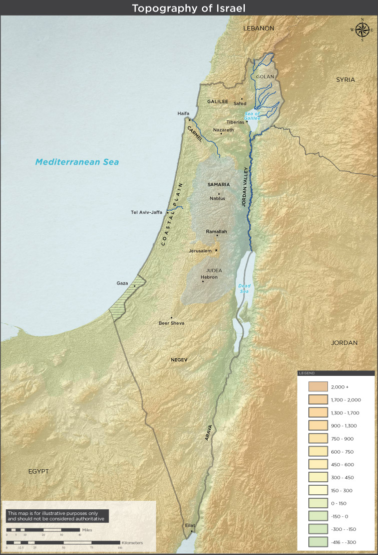
Topographical map of Israel, from the Israeli Ministry of Foreign Affairs
In Israel you can go down to the lowest point on Earth and swim in the briny Dead Sea, or go up high to a snow-capped mountain at Hermon for some skiing. You can immerse in the frigid groundwaters of the Arizal’s mikveh, or warm up in the hot springs of Tiberias. There are both forests and deserts, seawater and freshwater, lush hills and fertile valleys. Tiny Israel’s got a little bit of everything, a microcosm of the whole world. Most importantly, as the Torah says, prosperity in Israel depends entirely on God. It is not like Egypt or Mesopotamia, which gets cyclical, predictable river floods. Rather, Israel needs rain from above, and only God is in control of that. We see countless times in the Tanakh how, when God is displeased, He withholds the rains to dry out the land and force the inhabitants to flee—or perish. This land is especially connected to the Heavens, and the Torah tells us that “It is a land which the Lord your God looks after, on which the Lord your God always keeps His eye, from the beginning of the year to the end of the year.” (Deuteronomy 11:12)
There is much more to the uniqueness of the Land of Israel. Our Sages state that the very air of Israel “makes one wise” (Bava Batra 158b). Commenting on the verses in our parasha, the great Or HaChaim (Rabbi Chaim ben Moshe ibn Attar, 1696-1743) adds that being in Israel also purifies one’s soul. This is partly based on a debate of our Sages in the Talmud Yerushalmi (Kilayim 43a) where Rabbi Bar Kiria and Rabbi Elazar see coffins being brought in from outside of Israel to be buried in the Holy Land. Rabbi bar Kiria looks upon them disdainfully and recites the verse “…you came and defiled My land, You made My possession abhorrent.” (Jeremiah 2:7) Rabbi Elazar counters that when these bodies are brought to Israel, the Holy Land purifies them, as it is written “… and the Land atones for its people.” (Deuteronomy 32:43)
The Midrash states that true prophecy is only possible in the Land of Israel (Yalkut Shimoni, Ezekiel 336). In ancient times, receiving semicha and bearing the title “rabbi” was also possible only in Israel—which is why the Babylonian Sages generally went by the title “rav”, and not “rabbi” (for more on this, see here). Of course, many of the 613 mitzvot are only possible to fulfil in Israel. Even today, when we don’t have a Temple, there are still some 26 mitzvot which can be done only in Israel (such as terumah, ma’aser, and shemittah). There is no doubt that the Holy Land is special. It is tabur ha’aretz, the centre of the world (Ezekiel 38:12). The question is: where exactly is the Holy Land? What are the actual boundaries and borders of Israel?
The Promised Land
The first time that the Torah describes the boundaries of the Holy Land is when God promises the land to Abraham: “On that day God made a covenant with Abram, saying, ‘To your offspring I assign this land, from the river of Egypt to the great river, the river Euphrates.’” (Genesis 15:18) A simple reading implies that the Holy Land stretches from the Nile to the Euphrates. Having said that, both of these rivers are very long, so where exactly would the borders extend to? This territory is far too vast and there is no indication that the Holy Land ever stretched so far. There are a number of other glaring issues.
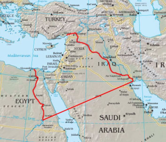
A supposed map of “Greater Israel” that you might find on Wikipedia
The Nile cannot be a boundary, since that would imply that when the Israelites were slaves in Goshen, northeast of the Nile, they were still within the Land of Israel! This is quite simply impossible. Moreover, the Torah makes a distinction between the “river of Egypt” and “the great river, the river Euphrates”, implying that the “river of Egypt” is not as great as the Euphrates. The Nile is certainly as great—if not greater—than the Euphrates. Lastly, when the Torah speaks of the Nile in relation to the Israelite slaves and the river turning to blood, it calls it the ye’or, not the “river of Egypt”. Therefore, the evidence is abundant that the “river of Egypt” cannot be the Nile. Sa’adia Gaon (c. 882-942), who was himself from Egypt and knew the geography well, identified the “river of Egypt” as Wadi el-Arish, a flourishing oasis close to the border of the modern State of Israel. This makes the most sense, and would serve as the border between ancient Egypt and ancient Canaan/Israel, hence “river of Egypt”.
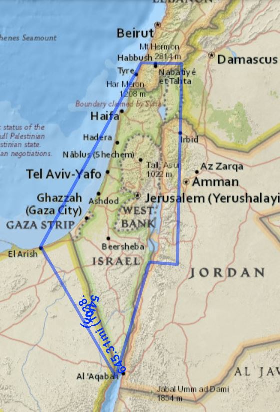
What about the Northern and Eastern border? In Numbers 34, the boundary is given this way:
This shall be your northern boundary: Draw a line from the Great Sea to Mount Hor; from Mount Hor draw a line to Lebo-hamath, and let the boundary reach Zedad. The boundary shall then run to Ziphron and terminate at Hazar-enan. That shall be your northern boundary.
For your eastern boundary you shall draw a line from Hazar-enan to Shepham. From Shepham the boundary shall descend to Riblah on the east side of Ain; from there the boundary shall continue downward and abut on the eastern slopes of the Sea of Kinneret. The boundary shall then descend along the Jordan and terminate at the Dead Sea. That shall be your land as defined by its boundaries on all sides.
The “Great Sea” is the Mediterranean, and the northern boundary stretches from the Mediterranean coast horizontally to Mount Hor. Note that this is not the same Hor as Hor HaHar where Aaron died. Some have identified this Hor in the Amanus mountain range in the north. In later Rabbinic texts, Hor is called “Amanah” suggesting that it may indeed be in the Amanus range. However, the Amanus range is much too far north, in southern Turkey. The Torah says a line should be drawn from Hor down to the “eastern slops of the Sea of Kinneret” (ie. the Galilee), which is roughly the Golan Heights area. To extend a line down from Amanah would likely result in encompassing Damascus within the boundaries of Israel, which cannot be since there is no indication anywhere in Scripture that Damascus is part of the Holy Land. Damascus was always indisputably the capital of Aram.
I think it makes more sense for Hor to be identified with Mt. Hermon. Hermon is the tallest peak in the region (both in Israel and Syria), so would serve as a clear boundary. It was considered a holy mountain for various ancient religions, and is even mentioned in the Epic of Gilgamesh, so it would have been well-known. After all, Hor would have had to be a mountain that everyone was familiar with (and one that no one could confuse with Aaron’s Hor). Therefore, it is most logical to identify it with Hermon. This avoids the problem of encompassing Damascus, as well as Sidon on the west coast, which was always Phoenician territory. The Tanakh states that Joshua conquered the land “up to Sidon”, and not past it (Joshua 11:8, 19:28). This further confirms Hermon as the northern boundary. (The only remaining issue with this is that there is no way to extend the border to the Euphrates, more on this below.)
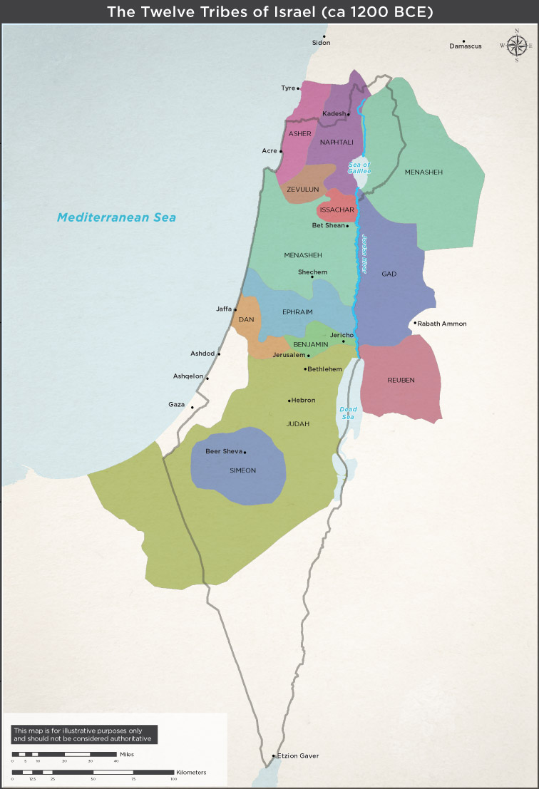
Ancient boundaries of the Twelve Tribes of Israel, from the Israeli Ministry of Foreign Affairs
Interestingly, with Hermon as the northern boundary, and the border being horizontal to the Mediterranean, it implies that what is today southern Lebanon was also part of ancient Israel. This is actually well-known, those lands corresponding to the territories of the tribes of Asher and Naftali, as well as a piece of Dan. More intriguing still, David Ben-Gurion sought to annex this territory to Israel. In 1956, while Israel was planning the Sinai campaign with British and French forces, Ben-Gurion presented his “grand design” for reorganizing the Middle East and fixing the boundaries that the colonial powers had so poorly misdrawn. In his 1997 International Affairs article on the 1956 negotiations of Sevres, Avi Shlaim noted:
Jordan, [Ben-Gurion] observed, was not viable as an independent state and should therefore be divided. Iraq would get the East Bank in return for a promise to settle the Palestinian refugees there and to make peace with Israel while the West Bank would be attached to Israel as a semi-autonomous region. Lebanon suffered from having a large Muslim population which was concentrated in the south. The problem could be solved by Israel’s expansion up to the Litani River, thereby helping to turn Lebanon into a more compact Christian state. The Suez Canal area should be given an international status while the Straits of Tiran in the Gulf of Aqaba should come under Israeli control to ensure freedom of navigation…
Ben-Gurion argued that his plan would serve the interests of all the Western powers as well as those of Israel by destroying Nasser and the forces of Arab nationalism that he had unleashed. The Suez Canal would revert to being an international waterway. Britain would restore her hegemony in Iraq and Jordan and secure her access to the oil of the Middle East. France would consolidate her influence in the Middle East through Lebanon and Israel while her problems in Algeria would come to an end with the fall of Nasser. Even America might be persuaded to support the plan for it would promote stable, pro-Western regimes and help to check Soviet advances in the Middle East.
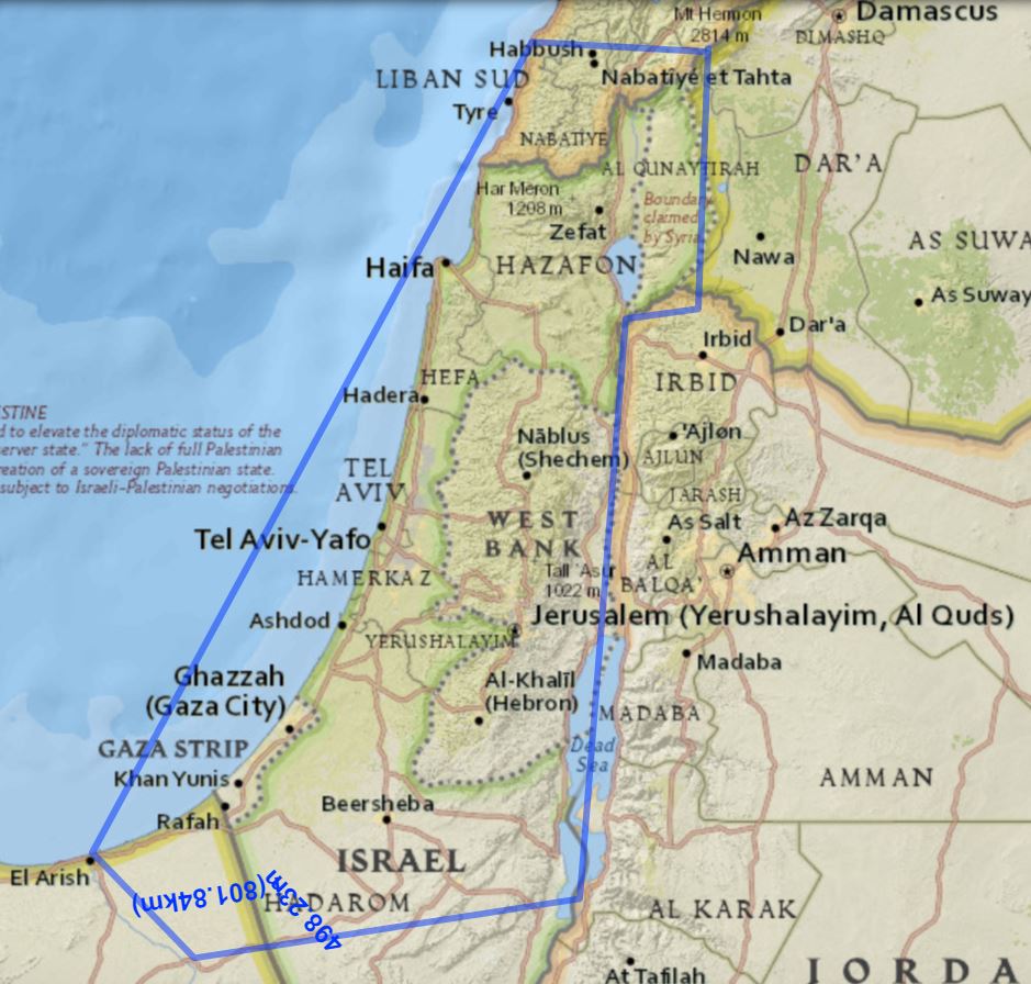
Ben-Gurion’s ingenious plan did not play out. The English and French were reluctant to make so many changes and, as history would prove, the United States strongly criticized the England-France-Israel alliance and pushed them to immediately end the Sinai campaign and withdraw. Based on the original plans, Israel was meant to annex all the territory up to El-Arish and Sharm el-Sheikh. It appears that Ben-Gurion also held El-Arish to be the rightful western boundary of Israel! He also had no plans for the territory east of the Jordan, although it was originally part of the British Mandate. Once again, Ben-Gurion’s vision fit with the boundaries in the Numbers 34 passage, above.
Meanwhile, the Torah says that Israel’s eastern boundary descends down the Jordan River and ends at the base of the Dead Sea. We know that the tribes of Reuben, Gad, and half of Menashe ended up settling the territory east of the Jordan, even though it was not part of the Promised Land. The Torah implies that the southern boundary is the base of the Dead Sea. In many places, Scripture states that Be’er Sheva is the southernmost city in Israel (see, for instance, Judges 20:1 or I Kings 5:5). This means that most of the Negev was not part of the Holy Land, and neither was Eilat on the Red Sea. In that case, the best estimate for the original Holy Land would be:
The original boundaries of the Holy Land (made using National Geographic’s MapMaker Interactive).
Settled Territory & Future Territory
During Israel’s kingdom period, the borders expanded. King David subdued the Philistines in the west, Edom and Amalek in the south, and Moav and Ammon in the east. His son, King Solomon, expanded Israelite settlements into the Negev. Today, on the way to Eilat, one can visit the mines of Timnah that were established by Solomon. The Tanakh also tells us that Solomon built a port on the Red Sea called Elot, what is today Eilat (I Kings 9:26). It appears that the territory south of Be’er Sheva was now absorbed into Israel. Over time, it took on an aspect of holiness, too, like the lands of Reuben, Gad, and Menashe east of the Jordan. This was prophesied in Exodus 23:31, which states that Israel’s borders would eventually be “from the Red Sea to the Sea of the Philistines [ie. the Mediterranean], and from the Wilderness to the River.”
The River in question is probably the Jordan though some, like Rashi, interpret it to mean the Euphrates. The latter interpretation allows for including the eastern territories beyond the Jordan—those of Reuben, Gad, and Menashe—within the Promised Land. The notion that the borders of the Promised Land can expand has a basis in the Torah, which opens the possibility for “when the Lord your God enlarges your territory, as He swore to your fathers, and gives you all the land that He promised to give your fathers, if you faithfully observe all these commandments…” (Deuteronomy 19:8-9)
In the future Messianic Age, the Tanakh (as in Jeremiah 31:16) prophesies that all of the ancient tribes will return to their ancestral borders. This implies that Reuben, Gad, and half of Menashe will return to their lands east of the Jordan. The tribe of Shimon that mostly settled Be’er Sheva and the Negev to the south will return to those lands, too. (On David Ben-Gurion again, he believed that the Negev is where Israel’s true potential lies, and himself settled and lived out his life there.) So, the final borders of the future, renewed Kingdom of Israel must include these territories.
Some push it even further, and state that the future “Greater Israel” really will extend to the Euphrates, as God promised to Abraham. While such “Greater Israel” maps (as shown above) appear all over the internet, both in right-wing Zionist and anti-Zionist websites, there is little foundation to this in Jewish texts. As we have seen, the “river of Egypt” is not the Nile, and what is meant by God’s promise to Abraham regarding the Euphrates is probably not what most think:
It is important to keep in mind that God reserved the land up to the Euphrates for all of Abraham’s “seed”. Recall that in his later years, Abraham had many more children and sent them to settle lands east of the Jordan, leaving the Holy Land specifically for Isaac. So, it is quite likely that God’s promise to Abraham was already fulfilled through those other children that settled the lands east of the Jordan all the way to the Euphrates. This is supported by a statement in the Yerushalmi (on Challah 8:2, as noted by Torah Temimah) pointing out that God said l’zara’acha natati, and not l’zara’acha eten, meaning it was not said in the future tense about a future time, but in the present, as if God had already given it. So, that land was never meant for Isaac, or his descendants through his son Israel. It was for Abraham’s other descendants (including Ishmael), as it remains to this day.
In political contexts today, the term “Greater Israel” (Israel HaShlemah) usually just means Israel including all of Judea and Samaria (“the West Bank”) and Gaza. It was a key part of the old Likud political platform. However, in 2005 Ariel Sharon gave up on Gaza, and by 2008 Ehud Olmert stated that “Greater Israel is over. There is no such thing. Anyone who talks that way is deluding themselves.” Nonetheless, the modern political Greater Israel more or less corresponds to the greatest extent of the Holy Land based on ancient sources (minus small parts of Lebanon, Jordan, and the Sinai), as explored above. Thus, we can formulate a map of the full Holy Land as looking something like this:
The greatest extent of the Holy Land of Israel (map made using National Geographic’s MapMaker Interactive).
Presently, it is not something that the State of Israel seeks to accomplish, or could ever accomplish on its own. It would require the return of Divine Revelation and the coming of Mashiach, the re-establishment of the Davidic dynasty, and a world that finally “beats its swords into plowshares” to achieve true, everlasting peace.
The above essay is adapted from Garments of Light, Volume Three.
Get the book here!
Pingback: Where Was the Garden of Eden? | Mayim Achronim
Pingback: The Encoded Journeys of Israel | Mayim Achronim